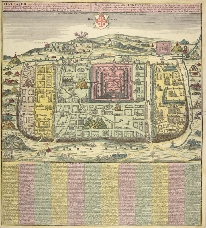
Ierusalem cum Suburbiis... [Jerusalem with suburbs...]
Book Description
Birds-eye plan after Andrichomius, (580 x 495 mm), with 12 columns of text below, title panel in Latin and German above, engraved plan with full original hand-colouring, central horizontal fold, three short marginal splits. Framed and glazed.
Dealer Notes
Plan of ancient Jerusalem and its suburbs, drawn after the earlier Van Adrichom's plan from 1584. This plan was copied by a number of early mapmakers (such as Jodocus Henricus Kramer and Jan Jansson) for their works on the Holy Land. The 1584 version of the plan was issued in the Theatrum Terrae Sanctae et Biblicarum Historiarum by Adrichom in Koln. Adrichom (1533-1585) was a Dutch priest whose scholarly research of the Bible and writings of pilgrims and Josephus made him the acknowledged expert on Holy Land geography.
The plan of the city surrounded by many illustrations of biblical and historical interest. It depicts sites and scenes of Jerusalem and its surroundings, which are numbered and identified by two hundred and seventy captions in German, referring to various events from the Old and New Testament. Although the title states that the plan refers to Jerusalem at the time of Christ, there is no chronological order to the scenes, as scenes from the life of Christ appear alongside scenes from the Torah, and ancient characters appear alongside European architecture and characters of the sixteenth century.
Georg Matthaus Seutter (1678-1757) was one of the most prolific map publishers in 18th century Germany. He started his career as a brewer but uninspired by the beer business became an apprentice engraver under the prominent German cartographer J. B. Homann. He later opened his own dealership offering custom made atlases, assembled by request. By 1732 Seutter was one of the most prolific publishers of his time and was honoured by the German Emperor Charles VI with the title of ‘Imperial Geographer’. Although not dated, we know the offered plan was created after this appointment, based on Seutter’s signature.
Author
SEUTTER, Georg Matthaus.
Date
circa 1735
Publisher
Augsburg,
Friends of the PBFA
For £10 get free entry to our fairs, updates from the PBFA and more.
Please email info@pbfa.org for more information
