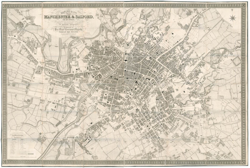
Plan of Manchester and Salford with their Environs

Book Description
Large engraved plan, dissected and mounted on linen, extending east to west from Salford to Beswick and north to south from Cheetham to Hulme, edged with green silk, folding into grey marbled endpapers. Dimensions: 1260 by 1900mm (49.5 by 74.75 inches). Scale: 1 inch to every 90 yards.
Dealer Notes
A rare wall map of one of the main centres of the Industrial Revolution, at the height of its development.
We could only trace four copies in institutions: two in WorldCat (Manchester and Cambridge), as well as one in the British Library and one in Chetham Library.
This large-scale plan of the city was published when Manchester became the most productive centre of cotton processing, and later the world’s largest marketplace for cotton goods. The city’s leading position for textile manufacture earned it the names ‘Cottonopolis’ and ‘Warehouse City’. This map, following the tradition of detailed city wall-map makers – such as Greenwood, for instance – thus testifies to the urban changes the city underwent: new manufactures and warehouses are pictured, as well as worker’s accommodations. Very detailed, it pictures every building precisely, and cotton mills, silk mills, vitriol works, dye works and more are referenced, some of them absent from the Swire 1924 map of Manchester.
John (d.1831) and Alexander (1797?-1870) Walker were father and son, two chart makers working as ‘J. & A. Walker’ in London and Liverpool. Alexander, who was probably in charge of the Liverpool branch, also worked with his two brothers John and Charles, established as ‘J. & C. Walker’ in London. Both companies worked for the British Admiralty.
A fine, fresh example of this impressive cartographic achievement.
Author
WALKER, J[ohn] and A[lexander].
Date
1832
Publisher
Manchester, Bancks & Co, Exchange Street,
Friends of the PBFA
For £10 get free entry to our fairs, updates from the PBFA and more.
Please email info@pbfa.org for more information
